Showing posts with label suburbs. Show all posts

Thursday, January 5, 2017

British Settler John Parkin's farm

This morning a quick Geocaching outing took me to a small park in Fernglen where I found an equally small monument located to the one side of the park.  The monument stated:

IN MEMORY OF 
JOHN PARKIN
1787 - 1856
LEADER OF A PARTY OF SETTLERS
FROM DEVON TO SOUTH AFRICA IN 1820,
AND PROMINENT IN THE EARLY 
DEVELOPMENT OF PORT ELIZABETH
THE SUBURBS IN THIS AREA
STAND ON WHAT WAS ONCE
JOHN PARKIN'S FARM OF 1421 H.A.
WHICH HE ACQUIRED IN 1826.

I never knew this little monument was here not that the suburbs in the area (probably Fernglen, Sunridge Park and Framesby) is located on what was once a Settler farm.  Just shows once again that there are still things in Port Elizabeth even I haven't discovered and how big a role Geocaching can play in discovering these places.

You can see how dry it is in Port Elizabeth at the moment by looking at the grass.  Brown and dry.

Sunday, October 9, 2016

The flowers in Mandelakwaland

About two weeks ago I received a mail from regular PE Daily Photo follower Gerhard Burger (and apologies to Gerhard for not replying but my laptop has packed up and I haven't been able to reply to emails from my phone.  At least I've been able to upload the pic from my phone to the blog).  He took this picture in one of the parks in Glendinningvale.  Much cheaper to view flowers in PE like this than to travel to Namakwaland.

Monday, September 12, 2016

Central view

I sometimes think I don't do nearly enough urban photography.  I was waiting for a meeting in Richmond Hill last week and went for a quick walk around the block with my camera and snapped this pic looking across towards Central and the Donkin Reserve.  I really like the mix of urban and nature with the flowering Coral Tree.

Sunday, September 4, 2016

Kamma Heights view

I went for a walk on the hillside above Kamma Heights yesterday in search of a Geocache and some alone time and this is the view that greeted me from the cache location.

Tuesday, May 17, 2016

The lake at Mount Pleasant

If you enjoy photographing birds and is looking for a nice urban location around Port Elizabeth to do so then you don't need to look any further than Lovemore Lake at the bottom of Boundary Lane in Mount Pleasant.  Every time I pass there I'm amazed at the amount of different birds around. On Saturday morning I passed there and noticed a number of them including what looked like a Goliath Heron.

Wednesday, August 14, 2013

Cotswold Quarry

Situated next to the suburb of Cotswold is the Cotswold Quarry where they collect supacrush for building purposes.  I got to this lookout area with fellow geocacher Seekoei the other day on a caching expedition.  Even though I've always known that it's there I actually don't know much about the quarry and thought to consult my good friend Google.  Unfortunately he didn't know anything either. 

There seems to be one more informed that my friend Google and that is regular PEDP reader Grant Slater.  He sent me the following:

It is called "Moregrove Quarry" owned by Lafarge Aggregates.  A brochure titled "Moregrove Quarry: 50 Years" was published in 1992.  Which would make the quarry 71 years old this year.  The quarry is on the Moregrove Fault.

He also sent me a link to an online article on the Moregrove Fault and I quote the following from it.

"There are three ancient fault lines in Port Elizabeth where some slight movements can still occur. One of them, the Moregrove fault, runs along the Port Elizabeth beachfront from Pollok Beach, Summerstrand, along the shoreline, through the Baakens Valley and ending at the Moregrove quarry near the Kragga Kamma interchange. The water which continually runs across Lower Valley Road near the old PE Tramways building is underground water seeping to the surface through the Moregrove fault. Another, the so-called Chelsea- Noordhoek fault, runs parallel to the Schoenmakerskop coast, while a third fault runs in the Coega area."
 

Friday, May 3, 2013

Country road

I have always loved the Chelsea and Deer Park area.  Country living, beautiful views and nature all around.  All of this just a stone's throw from the city.  This is Old Seaview Road running through Chelsea.

Friday, July 27, 2012

Beautiful Thursday sunset

Over the last week or so we've had a number of stunning sunsets here in Port Elizabeth.  Unfortunately I was just never in a position to get a photo, but that was until last night.  I spotted the sky changing colour through the lounge window, grabbed my camera and ran out into the street.  And presto, here it is straight out the camera with no adjustments made.

Saturday, July 21, 2012

South End street view

I took a couple of my colleagues on a walk around the South End Museum Heritage Trail with stops at some of the main heritage sites along the trail.  After looking around the St Peter's Church ruins this was the view as we were heading down the street towards Walmer Boulevard.  I kinda wish I lived this close to the beachfront.

Sunday, June 17, 2012

City farm

Port Elizabeth may be the 5th largest city in South Africa, but the Nelson Mandela Bay metropolitan area of which Port Elizabeth is part of is the second largest metropolitan in area size.  This means that the city has huge areas taken up by farms and small holdings.  These are areas like Greenbushes, Rocklands, Theesecombe, Bushy Park and Sardinia Bay.  The picture was take from the top of Heatherbank Road between Lovemore Heights, Charlo and Lorraine.

Wednesday, July 6, 2011

Farm in the city

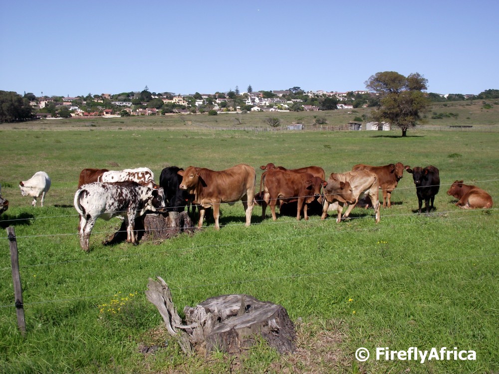
I often say that Port Elizabeth may be a full blown city, but its still a town at heart.  Or in this case a bit of rural as well.  Driving up Heatherbank Road between Charlo and Lorraine, one can easily forget that you are still in the city.  The farms and small holdings in this area have a lot of horses, but also cows and other animals on them.  I stopped to snap a pic of these young cows with the upmarket suburb of Lovemore Heights in the background. 

Saturday, June 18, 2011

Kelly Vlei

A weekend or two ago we attended a birthday party at Mike's Kitchen on Buffelsfontein Road in Mount Pleasant.  I grew up in Mount Pleasant so the area holds many good memories and looking out the restaurant's windows I saw one (or what's left of it) of the many place that form part of those memories.  We used to sit next to Kelly's Vlei many afternoon's fishing with hand lines and trying to see who caught the most of the little fish in the dam. (We obviously threw them back as there were now way you could eat those little fish)  Unfortunately the whole vlei (dam) has been choked by reeds and there doesn't seem to be any plans to clear it at the moment.  Sadness...

Wednesday, June 1, 2011

Pink Winter (not Spring) flowers

Looking at the grassy areas around town one would hardly say that today is (officially) the first day of Winter.  After all the good rains we've been having lately there has been a lot of little pink, white and some yellow wild flowers blooming all over town.  I found this patch in a play park in Charlo and, unlike fellow photographer Luc Hosten, I didn't have mommies from the nearby school look at me funny for crawling around the flowers with a camera in hand and their kiddies mere meters away.  Why not? Well, firstly I took Drama Princess along as my alibi and secondly I was there on a Saturday.

Tuesday, March 15, 2011

Sunday afternoon ice cream

I remember how we bought ice creams from the ice cream man on his bicycle on Sunday afternoons when we were children.  You could hear the bell ring as he came around the corner and if we were allowed to buy an ice cream we would run out to the gate as fast as possible to stop him before he passed.  The ice cream man still makes his rounds on Sunday afternoons.  We don't get him down our street as often as I did when I was small, but my kids know the bell and they know the drill.

Saturday, August 14, 2010

Bench with a view

Every now and then I get a request via e-mail from people who used to live in Port Elizabeth asking me to take a photo of a spot that holds a significant place in their memories. I have to be honest and say that I haven't really made lots of effort to go out and look for those places, but that is now changing. Over the last week or so I have spent my lunch hours looking for places and graves all over PE and these photos I will be posting from time to time.
.
I received e-mails from Darin and Mike within days of each other both asking me to post a pic of a spot at the end of Mill Park Road in Mill Park. Both said that the spot was the ideal place to just sit and wind down after a hard day. The view from the bench takes in the Baakens Valley with Walmer on the other side.

Sunday, September 6, 2009

Dusk on Lovemore Heights

The suburb of Lovemore Heights is one of Port Elizabeth's upmarket suburbs and is probably the highest spot in suburban Port Elizabeth. It has a fantastic view which ever way you look. I got this picture looking west just after sunset on the evening I took the pic of the moon rising over Port Elizabeth.

Thursday, February 19, 2009

Mill Park #4


The most well known feature of Mill Park is the Grey School. Here we are looking at the back, from a viewpoint in Mill Park, across one of the tributaries of the Baakens River, which has created many interesting ravines around the perimeter of the suburb. Note the security vehicle parked under the tree. A downside of the ravines is that they provide easy exit points for housebreakers to disappear into, so high walls, armed response, electric fences etc have sadly become part of the picture now.

Wednesday, February 18, 2009

Mill Park #3

As described in the first post 2 days ago, Mill Park is on the edge of the Baakens Valley. So from many streets in the suburb, you get glimpses of the hills across the valley, and many houses, such as these, have lovely views into the kloofs, and the opposite cliffs.

Tuesday, February 17, 2009

Mill Park #2


Established a century ago, Mill Park still has the atmosphere of a gracious lifestyle when life was lived at a slower pace. The lovely well established trees which line the streets soften the effect of all the high walls in front of the homes, and the trees popping over the tops of the walls give a sort of "secret garden" intrigue as you drive along.

Monday, February 16, 2009

Mill Park

Since we recently welcomed anon and arnieo to this blog, both of whom coincidentally live in Houston Texas and used to live in the PE suburb of Mill Park, we thought we'd show a couple of views of this attractive suburb.
Mill Park has an interesting history. According the the fascinating "Port Elizabeth in Bygone Days, written in 1947 by JJ Redgrave, "the present Mill Park area derived its name from the fact that there was in the early days an old Mill on the land overlooking the Baakens River"


In 1839 Mill Property belonged to Hougham, and the Government rented it, with the old mill and a small shanty house, as the Baakens River Leper Institution. By 1846 the Government had decided to move all the lepers and paupers to the leper colony on Robben Island.


The first areas to develop in Port Elizabeth were Central and Richmond Hill, Central being where the settlers who arrived in 1820 began building their homes, and part of Richmond Hill being set aside as the "Location for Native Strangers". We have dealt with this in previous posts.

As the town grew and more labourers were required to work on the development of roads and infrastructure, as well as the thriving port, the space in Richmond Hill became too small. By 1863 the Mill Farm was owned by a Town Councillor Mr T. W. Gubb, and he applied for permission to have Xhosa workers build huts on his land. It became home to around 800 squatters, and became known as "Gubb's Location". Gubb sold the land in 1867, but the name stuck.
Eleanor Lorimer, in her book Panorama of Port Elizabeth, describes conditions in the Location as "unsightly and verminous. There were no roads, no drains, no lights of course, and water and sanitary arrangements were primitive. "
This led to an outbreak of Bubonic Plague, and the location, by then owned by the Mill Park Estate and Land Company, was closed by the Plague Board in 1903, and the residents re-located to Red Location.

In the early 1900s the area was subdivided, and large houses were built, like the Old Mill House, shown above.